Homogenized record of tropospheric aerosol for reanalyses and reforecasts

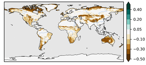
Decadal variations of tropospheric aerosols can have a strong impact on the production of reanalyses and seasonal re-forecasts. In preparation for the next generation of C3S products, CONFESS has produced a homogenous and consistent multi-decadal record of tropospheric aerosols, exploiting the atmospheric composition capabilities that the Copernicus Atmosphere Monitoring Service (CAMS) has been developing in the Integrated Forecast System (IFS-COMPO). A time-varying climatology of multiple aerosol species is calculated from data from a multi-decadal set of model  forecasts constrained by ERA5 meteorology, and with continuously evolving chemistry and aerosols driven by specified emissions. So far, we have considered the periods 1971–2019 forced by CMIP6-style emissions data (the latest version of CEDS, together with GFED for fire emissions), and 2003–2020 forced by CAMS emissions. Creating data back to 1940 will be straightforward once the ERA5 reanalyses are complete for that period. The aerosol records are then smoothed with a nine-year running mean to represent decadal variability. The resulting product has the added advantage that the last nine years can be used as a representation of the current climate aerosol values for NWP. We plan to use time-varying aerosol climatologies produced in this way for the ECMWF model versions that will be used for the next generation of ECMWF seasonal forecasts SEAS6 and the upcoming C3S reanalyses ERA6. Having an up-to-date aerosol climatology that is consistent with the latest CAMS aerosols is also helpful in allowing us to explore the impact of interactive aerosols on numerical weather predictions

 Change in July vertically integrated aerosol [mg/m2] between 1975 (left) and 2015 (right) for selected aerosol species. The effects of increased forest fires at high latitudes, changes in nitrogen chemistry affecting fine nitrate levels, pollution controls in Europe and North America, and emissions growth in India and the Middle East are all visible. Sulphate aerosols over China have peaked and are now declining.

Improved Vegetation Variability

A new deliverable presents the results of improved vegetation variability on surface fluxes modeled with offline land surface models. In this deliverable, we present the integration of the unprecedented vegetation information, from the latest satellite campaigns in the frame of Copernicus, into the land surface models (LSMs) used for reanalysis and initialization of the seasonal to decadal prediction systems. Observational Land Cover (LC) and Leaf Area Index (LAI) from CONFESS deliverable D1-1 are implemented as boundary conditions for the CHTESSEL (ECMWF), EC-Earth HTESSEL-LPJGuess (CNR) and the ISBA-CTRIP (Météo-France) land surface models. The effects of the improved representation of vegetation variability from observations on the LSMs has been evaluated in offline simulations forced by ERA5 atmospheric forcing.

Here we present the effects of seasonally and inter-annually varying LAI (sensitivity experiment), based on Copernicus observational data, on modelled evaporation, compared to evaporation modelled using seasonally varying LAI only (control experiment). Evaporation was evaluated using DOLCEv3 evaporation as reference. The figure below shows the effect of inter-annually varying LAI on the correlation of inter-annual anomaly evaporation for the three models with respect to the reference. The correlation consistently improves (blue colours) for ECMWF and CNR models, with the largest effects in regions with transitional climates. Also for the MF model considerable improvements were found.

The knowledge from the sensitivity analysis in this report is driving the selection of better solutions and configurations to include for the initialization/simulation of the predictions in CONFESS WP3. You can read more about the results in D1.2 Improved vegetation variability.

Year 1 highlights

The first period of the CONFESS project running from 1 November 2020 to 31 October 2021 has just concluded, and an impressive list of results has been achieved.

WP1

  • A harmonized observational Leaf Area Index (LAI) dataset covering the 1993-2019 period has been finalized and disseminated to CONFESS partners.
  • The Land Use / Land Cover (LULC) dataset has been adapted to IFS Vegetation Types and shared with partners
  • The FCover dataset has been retrieved and finalized to support modelling in task 1.2 and 1.3.
  • Annual maps of LULC derived from LUH2 have been produced consistently with SURFEX plant functional types
  • Vegetation and atmospheric input (ERA5 hourly forcing) have been prepared separately for each partner.
  • A list of land model output (variables, frequency) has been agreed and shared between partners.
  • Spin-up of Land-only simulations with prescribed LAI is about to be run.
  • Performed parameter estimation and optimization for the implementation of the effective vegetation-cover parameterization based on FCover and LAI data: the observational data of FCover was retrieved for the time period 1999-2019 and harmonized using a CDF matching approach consistent with what was done  by ECMWF for the LAI data .
  • The observational FCover and LAI data have been first categorized by land cover type as identified in the observational ESA CCI land cover dataset on a 9km (Tco1279) grid.
  • Performed a historical land-only simulation with interactive vegetation.

WP2

  • A new approach has been developed to derive a new version of the CAMS aerosol climatology, using the latest IFS version with full chemistry and aerosol, and including 14 aerosol types.
  • A new climatology will be derived over a multi-decadal period to allow the creation of a time-varying climatology, to obtain both a more accurate representation of the present -day climatology, and a much more accurate representation of the time-evolution at a regional scale.
  • A test-suite for this new approach has been successfully implemented.
  • A climatology was created from the Global Fire Assimilation System (GFAS) developed and maintained by CAMS, which is due to be made available in the Atmosphere Data Store.
  • Observed emissions from GFAS are already implemented in the IFS ENS which will be used to carry out the experiments.
  • The modelling first on FireCCI burned area at 0.25 deg resolution aggregated over 12 months periods centered around the peak month (for each grid point) has started.

WP3

  • The experimental protocol for the experiments in WP3 has been developed, covering all the experiments in the WP (Tasks 1, 2 and 3).
  • Production of re-forecasts with prescribed changes in land surface conditions will start in the second year of the project.

Vegetation dataset of Land Use/Land Cover and Leaf Area Index

A new deliverable provides the land use land cover data based on the ESA-CCI/C3S, and the Leaf Area Index data for the period of 1993 to 2019, based on harmonization of the CGLS/C3S data and the AVHRR based data. These data will be prescribed into the offline and coupled model to assess the impact of their inter-annual variability on reanalysis and seasonal forecast.

The Vegetation dataset of land use/land cover (LU/LC) and Leaf Area index (LAI) are essential for the CONFESS project. One of the main targets of this project is improving the usability of the information delivered across different Copernicus Services within the land-atmosphere coupled system. It aims at using new Earth Observations of LU/LC and vegetation states and the impact of their inter-annual variability on reanalysis and seasonal forecast.

CONFESS uses the LU/LC and LAI data from the Copernicus Climate Change Service (C3S) and the Copernicus Global Land Services (CGLS) for the period from 1993 to 2019. The LU/LC data is provided at a yearly frequency and adapted to the BATS classification as used within the ECMWF Integrated Forecasting System (IFS). The LAI data provided every 10-days, is extended from the 1999 to 1993 with the AVHRR-based data available through the C3S and interpolated to 1km spatial resolution. The harmonisation of the LAI data from the two data sources is assured with a CDF matching procedure.

You can read more about the datasets in D1.1 Vegetation dataset of Land Use/Land Cover and Leaf Area Index.

Experimental protocol for land and aerosol forcing re-forecasts

A new document has been published that provides a description of the re-forecasts planned in WP3 to assess the impact of improved boundary forcings in an initialized climate prediction setting.

Several sets of experiments are planned. A first category of experiments relate to developments in WP1 on the representation of time-varying land use and vegetation in land surface models and reanalyses, which are key ingredients for seasonal forecasting systems and multi-annual forecasting systems operated in the framework of the Copernicus Climate Change Service (C3S). Another category of experiments will evaluate the impact of tropospheric and volcanic aerosol forcing on seasonal and multi-annual experiments.

This document details plans for each model / system as of Month 9 of the project. In some cases, which are specified, some details of the experimental setup are yet to be decided based on results from analyses in WP1 and WP2. However, this deliverable provides a first framework for WP3 activities and leaves room for future adjustments, to be agreed among partners, when needed.

You can read more about the protocol in D3.1 Experimental protocol for land and aerosol forcing re-forecasts.

CONFESS Data Management Plan

The CONFESS Data Management Plan responds to the requirements of the H2020 Open Research Data Pilot to document which research data is being produced by the CONFESS project, in which format, and how it will be made available. It has already identified data sets for work packages 1 to 3, but is only to be seen as an initial version which requires periodic updates to provide the necessary detail as it emerges.

The data management plan, available here, provides details for the following data sets:

  • Leaf Area Index (LAI)
  • Land Surface Model Simulations
  • Land Cover
  • Land Use Harmonisation (LUH2)
  • Fraction of Vegetation Cover (FCover)
  • Harmonised CMIP6/CAMS time-varying climatology of tropospheric aerosols
  • Seasonal re-forecasts
  • Multi-year integrations

If you would like to know more about the data sets that will be made available, please contact us.

Planned results

CONFESS is an ambitious project with equally ambitious outcomes. CONFESS will produce:

Data sets

  • Mapping of harmonized multi-year records of vegetation (LAI) and land cover ready for ingestion by the CHTESSEL and SURFEX models, suitable for their use in reanalyses and seasonal forecasts. This should improve the temporal variations of land properties, with expected impacts on regional climate and hydrology.
  • A harmonized multi-year data record of tropospheric aerosol by merging CMIP6 and CAMS information. This should result in an improved and more accurate representation of the time variation of tropospheric sulphate aerosols, available for use in future reanalyses and seasonal forecasts, with potential for improving global trends and low frequency large scale climate variability. It will be the first attempt to create a seamless temporal record of tropospheric aerosols suitable for a range of applications: reanalysis, seasonal forecasts, near-term predictions and multi-year climate integrations.

Model capabilities

  • Improved parameterizations that allow for consistent time varying properties of land cover and vegetation, in CHTESSEL and SURFEX;
  • Vegetation models in CHTESSEL and SURFEX validated according to their impact on climate;
  • A more accurate representation of observed volcanic aerosol, built into the IFS and available for use in future reanalyses and seasonal re-forecasts. This should result in better representation of large scale low frequency variability, and reduction on the uncertainty of natural versus forced climate variability;
  • A low-cost predictive model for the evolution of volcanic aerosol after a major eruption, which produces data in an easy-to-use form for seasonal prediction models. This provides a capability for such systems to react to major volcanic eruptions;
  • A single-species aerosol model for biomass burning forced by prescribed fire emissions embedded in seasonal forecasting systems. This will enable seasonal forecasting systems to attribute impact of large biomass burning events on regional climate, and will prepare the ground for future C3S evolution.

Proof of concepts and prototypes for C3S

  • Prototype of a land reanalysis representing consistent temporal variations of land cover and vegetation for the period 1993-present.
  • Proof-of-concept for treatment of temporal variations of land properties -land cover and vegetation- and improved radiative forcing from tropospheric aerosols in a full reanalysis.
  • Prototype of next generation of seasonal forecasts with treatment of temporal variations of land properties -land cover and vegetation- and improved radiative forcing from tropospheric aerosols.
  • Prototype of volcanic aerosols prediction module interfaced with seasonal forecast. New capability for C3S.
  • Proof-of-concept module for biomass burning impact interfaced with seasonal forecasts. New capability for C3S.

Knowledge

  • Scientific validation of developments on land cover and vegetation variations.
  • Scientific validation of improvements in tropospheric and stratospheric aerosols.
  • Assessment of land and aerosol improvements on seasonal forecast skill, global trends and representation of regional extremes
  • Recommendations for implementation in the C3S systems