A new deliverable provides the land use land cover data based on the ESA-CCI/C3S, and the Leaf Area Index data for the period of 1993 to 2019, based on harmonization of the CGLS/C3S data and the AVHRR based data. These data will be prescribed into the offline and coupled model to assess the impact of their inter-annual variability on reanalysis and seasonal forecast.
The Vegetation dataset of land use/land cover (LU/LC) and Leaf Area index (LAI) are essential for the CONFESS project. One of the main targets of this project is improving the usability of the information delivered across different Copernicus Services within the land-atmosphere coupled system. It aims at using new Earth Observations of LU/LC and vegetation states and the impact of their inter-annual variability on reanalysis and seasonal forecast.
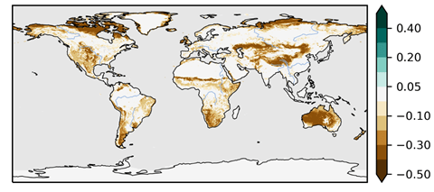
CONFESS uses the LU/LC and LAI data from the Copernicus Climate Change Service (C3S) and the Copernicus Global Land Services (CGLS) for the period from 1993 to 2019. The LU/LC data is provided at a yearly frequency and adapted to the BATS classification as used within the ECMWF Integrated Forecasting System (IFS). The LAI data provided every 10-days, is extended from the 1999 to 1993 with the AVHRR-based data available through the C3S and interpolated to 1km spatial resolution. The harmonisation of the LAI data from the two data sources is assured with a CDF matching procedure.
You can read more about the datasets in D1.1 Vegetation dataset of Land Use/Land Cover and Leaf Area Index.
